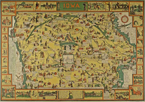
Mildred Pelzer of Iowa City created this map in 1934 featuring more than 250 locations or historical events. The map now greets visitors to the State Historical Museum of Iowa’s newest exhibit, “Iowa’s People and Places,” and offers a glimpse of some of the most important moments in Iowa history as we celebrate 175 years of statehood. Visit iowaculture.gov. Photo courtesy of State Historical Society of Iowa
By Andrew Klumpp and Leo Landis
On April 6, 1933, an artist named Mildred Pelzer of Iowa City recommended to a meeting of history enthusiasts in that city that drawings and illustrations of historic events from Iowa’s past be created to commemorate the 100th anniversary of the founding of Dubuque and Burlington. Pelzer took on the project in her own way creating an illustrated map of Iowa bordered by the Big Sioux, Missouri and Mississippi rivers, featuring each county seat and historical people and events across the state. The map now greets visitors to the State Historical Museum of Iowa’s newest exhibit, “Iowa’s People and Places,” and offers a glimpse of some of the most important moments in Iowa history as we celebrate 175 years of statehood.
“Iowa People & Places” is arranged chronologically and covers 13,000 years of Iowa history, from prehistoric times all the way through 2020. It includes topics and themes like Native peoples, statehood, religion, military service, immigration, civil rights, agriculture, industry and more. Like all exhibits at the museum, featured stories are based on photographs from the State Historical Society of Iowa’s libraries in Iowa City and Des Moines, holdings from the State Archives, and the museum collections. The exhibit also incorporates stories told through videos featuring the dynamic work of the Iowa Arts Council and Produce Iowa, the state office of media production.
Pelzer’s map in the new exhibit is inspiring, but it also has some noticeable omissions. It tells few American Indian stories, none focused on Black Iowans, and of course, doesn’t include anything after its creation in 1934. It is a provocative reflection of Iowa history and a starting point for conversations about the people and places that have shaped our state and nation. (The Iowa City holdings include a poster produced from Pelzer’s art.)
In selecting images and artifacts for a new exhibit, lecture, or educational program, the stories ought to reflect the iconic, the underappreciated and the everyday. Stories from across the state are important to the State Historical Society of Iowa. Archivists and exhibit-development staff are mindful of representing far-ranging stories.
Native Nations
The stories of Iowa’s Native nations are excellent examples of all three. The Meskwaki people’s persistence and ability to work within the construct of the U.S. and Iowa governments, for example, led to what is likely the first and perhaps only tribal nation in the U.S. to purchase land rather than rely on a reservation. This means, of course, that the Meskwaki Settlement has never been a reservation. An important pen-and-ink drawing that Meskwaki elder Wacochachi drew around 1830 documents the relationship between the Meskwaki and Euro-Americans and is believed to be a gift to a trader named George Davenport. The drawing depicts important events in Wacochachi’s life, including two scenes of warfare, as well as creatures that are sacred to the Meskwaki. It is a compelling visual representation of Mekwaki culture and one of the oldest extant drawings on paper by a Native person from the Midwest. It conveys the richness of Meskwaki beliefs and interaction with nature as well as indicating the contested existence of the Meskwaki people. It is a true privilege to have this drawing on display at the State Historical Museum of Iowa.
The current exhibit also features a “Map Showing the Lands Assigned to Emigrant Indians West of Arkansas & Missouri,” which reflects Native nations around 1835. It imprecisely shows the territories that the U.S. assigned to Native peoples, including the Winnebago in the northeast section of what is now Iowa; the Ioway, Sac, and Foxes (Meskwaki) in the central area; and the Potawatomi in the west. Another section of the map, in the northwest, describes land “ceded by the Sioux (Dakota, in this case), Sac, Foxes, Otoes, Ioways” and others in 1825. The map reflects the contested nature of the land claimed by indigenous nations and the United States.
The Dakota, located in Iowa’s northwest corner well into the 19th century, have also received important attention this year. In a recent article for The Annals of Iowa and related lecture for the State Historical Society of Iowa’s online series “Iowa History 101,” historian Kevin Mason brought renewed attention to the long history of the Dakota in Iowa. Mason’s work contextualizes the Dakota’s culture — their hunting practices, kinship networks, and deep connection to the Little Sioux River Valley — and documents a pattern of broken and disputed treaties that eventually displaced Iowa’s Dakota tribes.
TO READ THE ENTIRE STORY AND OTHER FASCINATING STORIES ABOUT IOWA HISTORY, subscribe to Iowa History Journal.
