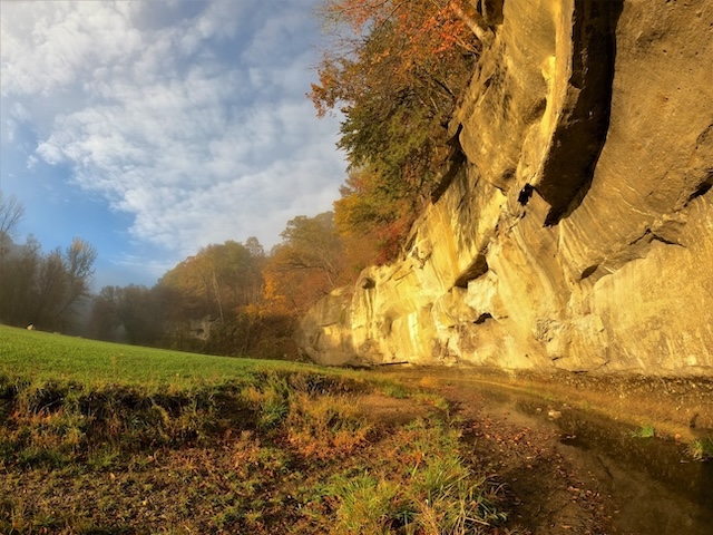
Ledges State Park, which celebrates its centennial in 2024, is one of Iowa’s most historic and unique nature destinations, especially for hikers and outdoor enthusiasts. Its four-mile trail system winds through steep slopes and scenic overviews, with sandstone ledges towering above the Des Moines River. Photo courtesy of Friends of the Ledges Facebook Page
July/Aug 2024 (Volume 16, Issue 4)
By Carson Ode
Iowa has rugged landscapes on its coasts—the Mississippi River on the east and the Missouri River on the west. In between is flat and rolling prairie of rich, black dirt. The ultimate in agriculture production has been developed to efficiently take advantage of this natural resource to help feed the world. Driving across Iowa today through the bountiful farmland, you unexpectedly come upon wooded valleys, rivers and creeks in wilderness patches. The Des Moines River bisects the state, from the northwest to the southeast, entering the Mississippi River at the southeast corner. It flows through a beautiful valley that is at its epic as it passes by Boone. Just south of this railroad town, Davis Creek joins Peas Creek to flow through a lovely sandstone gorge extending to the Des Moines River. In 1924 this area was dedicated as Iowa’s second state park given the name Ledges State Park. (Backbone State Park is Iowa’s oldest, dedicated in 1919.)
To approach Ledges State Park, take Iowa Highway 17 south from U.S. Highway 30 (between Ames and Boone) to County Road E52. Heading west on E52, you gaze at typical Iowa farm countryside as you approach the Ledges. The tall prairie grass growing around the Ledges State Park entrance sign signals the view is about to change. Following the road into the park, you pass some entrance structures including the check-in station. It was built in 1928 to be a gatehouse. It housed other uses over the years and is presently occupied by Friends of the Ledges, a nonprofit organization that advocates for the park and its resources and utilizes the building as a concession operation. Snacks and souvenirs are sold during the season. You also pass campgrounds before descending along Peas Creek into the gorge. Sandstone bluffs rise from the creek. Their linear shape with creases forming ledges give the park its name.
The advance and retreat of the continual ice sheets during the Quaternary Period formed this unusual cut into prairie land. The source for this article places the Quaternary Period from 2.6 million years ago to present. Scientists divide this period into the Pleistocene (2.6 million years to 11,700 years ago) and the Holocene (11,700 years ago to today). Meltwater during the last ice age, approximately 13,000 years ago, carved through glacial deposits, shaped the striking bluffs along Peas Creek. The power of water, flowing at a rate and volume much greater than we see today, cut ledges into the smooth, rounded, sandstone faces.
Archeological evidence points to humans appreciating the creek and bluffs as early as 4,000 years ago. European pioneers found Sauk, Sioux and Fox (now Mesquakie) inhabiting the area. American Indian mounds in the vicinity contain artifacts that contribute to the evidence of early humans.
Naturalists and outdoor enthusiasts enjoyed this natural aberration of the prairie before the Iowa state park era dawned in the 1900s. When the state began considering sites for potential parks, the Ledges rose to the top of the list. Local residents worked together to raise funds to make the initial purchase.
In 1921, 644 acres of this beautiful piece of land was acquired by the State of Iowa to preserve its unique character and provide for open space and recreational use. The 644 acres dedicated in 1924 was expanded to 860 acres in 1945. Lands recently donated by the U.S. Army Corps of Engineers, to mitigate for parklands flooded by the newly created Saylorville Lake, bring the park’s total acreage to 1,117 acres.
TO READ THE ENTIRE STORY AND OTHER FASCINATING STORIES ABOUT IOWA HISTORY, subscribe to Iowa History Journal.
